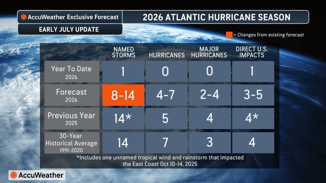
AccuWeather has slightly reduced its forecast for the number of named storms expected during the 2025 Atlantic hurricane season, citing the early arrival of El Niño and a 70 percent chance of a Super El Niño developing later in the year. According to Antigua News Room, the updated forecast now calls for 8 to 14 named storms, down from the initial projection of 11 to 16 storms issued in March.
"El Niño conditions have always been the driver for why we're expecting numbers near or below the historical average this year," said Alex DaSilva, AccuWeather's lead hurricane expert. "The stronger the El Niño gets, the fewer named storms we're likely to get. Back in 2015, we had a strong El Niño and got 11 named storms. I think that is the sweet spot again this year."
Despite the revised storm count, AccuWeather experts still anticipate 4 to 7 Atlantic hurricanes, 2 to 4 of which may reach major hurricane status, with 3 to 5 direct impacts on the United States. Higher-than-average risk areas include the northern and eastern Gulf Coast, the Carolinas, and the northeastern Caribbean — a region that includes Antigua and Barbuda — where storms can develop rapidly.
DaSilva warned that storms forming close to shore present a particular danger. "When tropical storms and hurricanes form close to the coast instead of tracking across the open Atlantic from Africa, there's a real difference in warning time," he said. "Residents may have significantly less time to prepare. That's why we stress having a hurricane plan in place before the season starts, rather than waiting until a storm is already offshore."
El Niño, which arrived in early June, is expected to generate increased wind shear across the Atlantic Basin, disrupting the formation and intensification of tropical systems. AccuWeather projects a 70 percent chance the phenomenon escalates into a Super El Niño, potentially lasting into early 2027. The overall pattern this summer and fall is expected to favour a lower-than-average risk of significant tropical impacts along the central and lower Texas coast.
However, forecasters cautioned that warm Atlantic waters near the U.S. coastline could allow storms to form and rapidly intensify closer to shore. They also noted that impacts can extend hundreds of miles inland through flooding rain and tornadoes, urging residents well away from coastlines to monitor forecasts closely.
The season's first named storm, Tropical Storm Arthur, underscored that danger. Arthur made landfall in Texas on June 17, delivering more than 20 inches of rain in some areas and causing an estimated $4 billion to $6 billion in total damage and economic loss, according to a preliminary AccuWeather estimate. The storm triggered extensive flooding, property and infrastructure damage, hundreds of flight delays, prolonged power outages, and widespread business disruptions.
"Arthur is another reminder that tropical systems do not need to reach hurricane strength to cause significant, expensive and even deadly damage and economic losses," said AccuWeather Vice President of Forecasting Operations Dan DePodwin. "Flooding, travel disruptions, power outages and business interruptions can quickly add up to billions of dollars in impacts for families, businesses and communities."
AccuWeather uses its RealImpact™ Scale for Hurricanes to assess storms, a tool that goes beyond the wind-speed-only Saffir-Simpson Hurricane Wind Scale by incorporating flooding rain, storm surge, and economic damage to provide a broader picture of a storm's potential impact on lives and livelihoods.